28/04/2022 10:08:34 AM
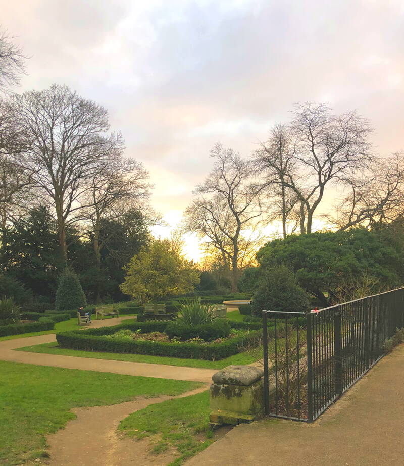
52. Centenary Park


This park is in Stanmore – we went there when I could turn right at the end of the road without Jack shouting “I told you to turn left” for the rest of the journey. The park is spacious and on a slight slope, and there is plenty of room to walk. This contrasts with some places we’ve visited lately, which comprise playgrounds (the reason I chose them) but little else. So, although we’ve now visited 153 parks, I won’t be writing about all of them, especially those on my list where I’ve commented “bleak”. Now that the days are longer and, I hope, the weather is improving, I am going to have to insist on our visiting places where we can walk, whether there’s a “big lying-down swing”, a “chair swing”, or not.
Centenary Park was added to the area’s public open space in 1934 when the local authority acquired the land. It’s called after the centenary of local government. Although the park is mainly a large open space, it has the remains of a formal layout with a tree set in a circular lawn near the main entrance and another bed planted with heather and conifers. A path around the edge is planted with London plane trees.
Centenary park has two floodlit football pitches available for hire, bowling green, tennis courts, pitch and putt golf course, exercise machines, and playgrounds for younger and older children. There are benches to rest on and paths for walking. This was good for us as quite a few places we’ve visited didn’t seem to have any paths and we have had to squelch our way across mud and waterlogged grass. But not at Centenary Park, where the paths are also wide enough for wheelchairs. Dog walking is allowed.
The park has a café, with space to sit outside. There are toilets. There is no car park but it’s possible to park on nearby streets. There are entrances from Burnell Gardens, Crowshott avenue and Culver Grove, Stanmore.
Judith Field
Centenary Park, 135 Culver Grove, Stanmore, HA7 2NW
07/04/2022 03:34:17 PM
51. Tudor Sports Ground


Tudor Sports Ground is a park in New Barnet. It’s a large, grassed area with scattered mature trees. It’s largely used for sport, but there’s lots of room to walk in. You might miss it if you looked for it on a map, because some only show the footgolf course in the park. It has eighteen holes and the game involves kicking a football into a hole (larger than in normal golf) in as few kicks as possible. Once inside the park, follow the signs to ‘The Field of Dreams’. There’s also a cricket pitch, tennis court, basketball shooting area and playgrounds for younger and older children.
Overlooking the park is a run-down nineteen twenties art deco pavilion. This is included in Barnet Council’s local heritage list as being of ‘historical and architectural interest because of its social and community value, its age and rarity, and its landmark qualities’. It’s not much of a landmark at the moment but there’s a campaign to renovate it. It might then be used to house one or more of a café, public toilets, community space, events space, social enterprise and changing facilities.
The space that makes up the park has been protected by the Fields in Trust charity since 1940 as a covenanted field. This means that there is a legal agreement between the landowner and Fields in Trust that the landowner will ‘retain it for use as a green space, usually a public park, playing field or recreation ground, in perpetuity.’
Tudor Sports Ground is one of sixteen Barnet's Premier Parks. Barnet describe them as ‘exemplar ideal parks which are attractive, accessible, well maintained and offer a wide range of facilities’. Barnet’s objective is to ensure that one is available within one mile of the majority of homes in the Borough. I don’t know whether they’ve met this objective, but if I do find the time and inclination to sit down with a map and compasses, I’ll let you know.
There are no café or toilets. The park has its own car park, and it looks as though it’d be easy enough to find spaces to park on the surrounding streets.
Judith Field
Tudor Sports Ground, Clifford Road, New Barnet, EN5 5JS
31/03/2022 05:09:44 PM
50. Whitings Hill Open Space and Whitings Wood


This large open space is in Chipping Barnet. It’s dominated by a rounded, grassy hill, which gives a good view over the surrounding area. The rest of the habitat consists of clumps of trees, and there are bramble patches. Part of Jack’s and my park visiting ritual is that, if we see blackberries growing, we always eat one each. Here, we found enough to fill a handkerchief to take home.
 It was quiet when we visited – we only saw about two other people there. There’d be plenty of room for dog walking and general running around (by people of any age who feel up to it). A small stream, a tributary of Dollis Brook (see Park of the Week 49), flows through the site. There are no snakes living in the stream, but I thought this branch looked like one.
Whitings Hill had previously been scruffy pastureland until Barnet Council turned it into a public open space in 1996 and invited local groups to plant trees there. The Barnet Society created two plantations on the south-west side of the hill, to mark the Society’s fiftieth anniversary. They made sure that all the trees in the plantations were native species. Whitings Hill School also planted trees on the north-west side.
Whitings Wood is next to the open space and was also created in 1996. It’s part of the Watling Chase Community Forest project. Community Forests are not continuous areas of closely grown trees but are instead meant to be ‘a rich mosaic of landscape, within which land uses include farmland, woodland, villages, leisure enterprises, nature areas and public open space’. Watling Chase covers an area in Hertfordshire and the northern edge of London, including in Barnet and Harrow. Local people engaged in the woodland creation from the outset. Whitings Wood contains a mixture of native broadleaf trees and woody shrubs. Blackthorn hedgerows are spreading out and natural regeneration is developing.
There’s access from Greenland Road, Shelford Road, Quinta Drive, Brett Road and Hackforth Close, all in Barnet. There’s space to park on the surrounding streets.
Judith Field
Whitings Hill Open Space and Whitings Wood, 9 Greenland Rd, Barnet EN5 3BL
25/03/2022 09:56:24 AM
49. Dollis Valley Greenwalk – selected bits


The Dollis Valley Greenwalk is a footpath route, set up in the London Borough of Barnet in the nineteen thirties. It runs for about 10 miles between Moat Mount Nature Reserve (in Mill Hill) and Hampstead Heath, passing through many green spaces and wildlife corridors along the way. The route mainly follows the course of Dollis Brook, which rises at Moat Mount near Arkley, meets the Mutton Brook at Hendon. There it becomes the River Brent, flows into the Welsh Harp Reservoir (see Park of the Week 10) and eventually into the River Thames at Brentford.
It’d take many hours to walk the whole length of the Greenwalk and we haven’t done it, but we have visited several places along the route:
• Fields next to Barnet Lane, where I took the photo of Jack we use for this blog;
• Brook Farm Open Space, where hay used to be grown for London’s horses;
• Riverside Walk, on each side of Argyle Road, Woodside Park. We went there early in the first lockdown when many people seemed to have decided to get out their bikes and we spent a lot of time jumping out of their way;
• A not particularly appealing section that runs alongside the Benighted North Circular Road and connects with Windsor Open Space (see number 21) – there’s an entrance at Henly’s Corner (where the A1 and the Benighted briefly meet) on either side of Finchley Road. Park where you can, then walk;
• Little Wood and Big Wood (see number 18);
• Whetstone Stray (or Strays). We spent the most time here. It’s parkland created during the twentieth century from former farmland. ‘Stray’ in this context means a common or piece of unenclosed land, on which there is a common right of pasture.
We accessed Whetstone Stray from Totteridge Lane, N20. It’s a meadow park, quiet and peaceful, with a wide, tree-lined footpath running alongside the brook. There’s plenty of room on the path for cyclists, dog-walkers, and others not to have to dodge each other. There’s no café or toilet.
I suppose Whetstone Stray could be said to separate Totteridge from Whetstone. We parked outside the shops on Totteridge Lane by Totteridge and Whetstone station, which is opposite the Stray and next to Brook Farm Open Space.
Judith Field
Whetstone Stray, Totteridge Lane, London N20 8HH
16/03/2022 05:12:31 PM
48. Waterlow Park

This park is in Highgate Village. It’s on a steep hillside and has some of the best views over London.
The land the park occupies has been laid out as gardens since the seventeenth century. It was formed from the combined grounds of five houses, including the poet Andrew Marvell’s cottage, and Lauderdale House. Sir Sydney Waterlow, businessman and Lord Mayor of London bought the properties and their grounds and in 1872 he leased them to St Bartholomew’s Hospital for patients who were convalescing. It was used for this until 1883. Waterlow gave it to the local authority in 1889, as a ‘garden for the gardenless’, as he put it. The park, described in the Illustrated London News as a ‘munificent gift of delightful pleasure grounds’ was officially opened in October 1891.
Lauderdale House still sits at the edge of the park and is now used as a tearoom and for functions and arts events. On the terrace is a large wrought-iron sundial with the hours marked by surrounding bedding plants.
The park has paths throughout and is landscaped with three ponds, one of which is designated as a restricted nature area. There are borders, grassy slopes, and a wide variety of trees. There are barbecue areas, and tennis and netball courts. Writing this takes me back to my Liverpool schooldays and memories of netball, running pointlessly up and down the playground in gym skirt and t shirt (tights not allowed) while the PE teacher stood shivering, anorak hood up, hands in pockets, shouting commands like ‘mark your partners’, through chattering teeth. I still think netball is a stupid game. The park also has an area for pétanque, which is more to my taste. I like to play boules – and to write it.
There are toilets in the park, and a café in Lauderdale House. There is also a children’s play area, with equipment for young children. This lack of large swings put Jack in a bad mood so we headed for home, which involved walking up a very steep hill. As Jack is not very fit and, when we visited, I was recovering from illness, before we reached the top we both sounded like Darth Vader. Luckily, there are plenty of benches to sit on.
There is parking on surrounding streets, although I imagine this could be hard to find. We were lucky enough to find a space on Highgate Hill. The nearest station is Archway, about a 10 minute walk away, or you can get a bus from there to the park.
Judith Field
Waterlow Park, Highgate Hill, London N6 5HG
10/03/2022 03:51:02 PM
47. Hilly Fields Park

I often find that people add a superfluous S to the end of my surname so I made sure that This park in Enfield really is called Hilly Fields rather than Hilly Field, who sounds like she might be a character in Malory Towers. Hilly Fields Park is a natural park in Enfield with fields, meadows, and woods. It’s been described as one of the most interesting grassland areas in the borough. There are many mature large old, pollarded trees and oaks. These are scattered over rough grassland, which contains a large range of plants and is home to butterflies.
The northern boundary of the park is formed by the Turkey Brook, which rises at Potters Bar, and eventually reaches the River Lee Navigation (a canal incorporating the River Lee) at Enfield Lock. The banks of the brook are dotted with hornbeam and scrub trees. Towards the east end of the park, at the top of a slope planted with trees that include oaks and conifers. The park is a Site of Local Importance for Nature Conservation.
The area it now occupies used to be known as Park Farm. The local authority bought 62 acres of the farmland, as part of their policy of acquiring land for public open space as the area was being developed for housing and they opened Hilly Fields as a public park in 1911. In 1921, because brass bands were becoming very popular. a wooden bandstand was built. Audiences fell to much lower levels in the nineteen thirties due to competition from cinema and radio and in the Second World War, bandstand entertainment was not promoted at all. Eventually the bandstand became derelict, but it was restored in 2001, using funds from the Heritage Lottery Fund. Bandstand events are held in the summer.
It is quite hilly and it’s a popular place for sledging when the snow comes.
The London Outer Orbital Path, usually known as the London Loop, runs through the park. This is a 150-mile signed walk along public footpaths and through parks, woods and fields around the edge of Outer London, sometimes described as “the M25 for walkers”.
Hilly Fields Park doesn’t have toilets or a café. Nor does it have a playground, but for once Jack didn’t seem to mind. There was so much space to walk in that I had to take note of landmarks, so we didn’t get lost. My sense of direction hasn’t improved since we got lost at the Hill House Pergola (see Park of the Week 3). I think that might make a good T shirt slogan.
Judith Field
Hilly Fields Park, Phipps Hatch Lane, EN2 0AG
02/03/2022 03:13:49 PM
46. Arnos Park


Jack asked to visit this park, which he’d apparently been to with his college a long time before. He didn’t know its name, describing it as “a park with a railway bridge near X and Y’s house” (in Whetstone) and I didn’t know which one he meant. His mixed-up directions took us to Cockfosters without finding the park, but on the way back (by which time he was extremely cross with me, and the only thing stopping me pulling my own head off was the fact that I was driving), we happened to pass what turned out to be Arnos Park – in Southgate. I hadn’t been there before.
Southgate was a settlement at the south gate of hunting park of Enfield Chase. Henry VIII confiscated the land, then owned by the Roman Catholic Church. It became the Arnos Grove Estate. In the late nineteenth and early twentieth century the large estates in the area were broken up as housing was built. Arnos Park was created in 1928 when an area of wood and meadow were bought by the local authority. The rest of the estate was sold for housing development. The “railway bridge” is the Arnos Park Viaduct on the Piccadilly Line, built in the nineteen thirties, which divides the park in two. With thirty-four arches, it’s the biggest brick viaduct ever built for the London Underground.
The park is long and thin, with a lot of open space. It’s a Site of Local Importance for Nature Conservation. Its woodland, running across the north end of he park, is believed to be ancient in origin, with trees including sessile oak and wild service tree (both uncommon in London), as well as hornbeam, wild cherry, and hazel.
It has a small stream – Pymme’s Brook, bordered with shrubs and willows. The brook has its source in Hadley Common, eventually joining the River Lea. Woodland flowers grow near it. A walking route, the Pymme’s Trail, follows the brook as far as Arnos Park.
It has tennis courts, cricket and football pitches, a children’s playground, a putting green, and a bowling club. There are toilets but no café. There’s no car park but it’s possible to park on the surrounding streets.
Judith Field
Arnos Park, 120 Morton Way, London, N14 7AL
24/02/2022 04:37:04 PM
46. Copthall Railway Walk & Copthall Old Common


This nature reserve starts at a bridge under Sanders Lane NW7, near Bittacy Hill, and finishes at Page Street. However, there is an entrance five minutes’ walk away from my house. You turn left (so no Jack complaints) at the end of my road (Salcombe Gardens), cross over Devonshire Road NW7 so that you’re on the same side of the road as Canada Villa Youth Centre, turn left and walk over the bridge. At the end of the railings on the bridge is a set of steps leading under the bridge. This is shown as a red pin on the map.
There, you come to a grassy footpath, the Copthall Railway Walk, following the route of the old railway line from Mill Hill East to Edgware. This line was meant to be incorporated into the London Underground system in the nineteen thirties, but it was only partly completed when war broke out. Afterwards, plans to make the rest of the line part of the tube were scrapped. Here and there you can see crumbling concrete posts which would have carried the cables for the railway if the electrification of this stretch had taken place.
Apparently, the existing stretch from Finchley Central to Mill Hill East was only completed because of the latter’s closeness to an Army barracks. That site has been recently redeveloped, but I do remember visiting the Garrison Nursery to get supplies of baby formula, over twenty years ago.
The nature reserve runs for just under a mile of the old line. Copthall Old Common is to one side, here the path broadens, then narrows again to follow a green lane. The habitats on the site include a mixture of re-grown woodland, scrub, and rough grassland as well as a small pond on the common, where there are older oak trees. Among the hedges grow oak, sycamore and silver birch trees and there are areas of bluebells. The site is also home to several species of birds and invertebrates, including slow worms and glow-worms, a scarce and declining species (we didn’t notice any).
There are no toilets, café, or playground with “lying down swings”. But you can’t have it all.
Judith Field
Copthall Railway Walk and Copthall Old Common, Off Pursley Road, London NW7

17/02/2022 10:00:53 AM
45. Chestnuts Park

This park is in Tottenham. I promise to write about a different area next time. My excuse is that we can get to Haringey by turning left at the end of our road – as I’ve mentioned before, Jack reacts badly to our turning right. I would rather endure driving on part of the Benighted North Circular than spend an entire journey with “I told you to turn left” blasting from behind me.
Originally the land that’s now Chestnuts Park was used to grow watercress – a crop which thrives in wet conditions. The Stonebridge Brook, which used to run through the park is now housed in an underground culvert. The brook rises in Crouch End and eventually joins the River Lea by Markfield Park (see Park of the Week 28), which joins the Thames.
In 1850, Chestnuts House was built on the land. In 1898 the local authority bought the house and land, and it was laid out as Chestnuts Recreation Ground to commemorate Queen Victoria’s Diamond Jubilee. The park opened to the public in November 1900. The house was at first used as a public reading room and museum, later becoming a health clinic. It was demolished in the nineteen eighties to make room for the Chestnuts Community Centre.
 Most of the park is grass. There are a lot of mature trees: London plane, common lime, cherry, silver birch. There’s also a community willow garden and an orchard of fruit trees. People from the local community have planted bulbs and there are flower beds. The park was first awarded the Green Flag Award in 2008 and has kept it ever since. It’s a Site of Importance for Nature Conservation because it’s a sizeable park with plenty of mature trees and areas of long grass, in a part of Haringey with little accessible natural greenspace. It is also a Field In Trust. This means it is protected in perpetuity (at least that’s the idea) as a site for public recreation, as part of the Queen Elizabeth II Fields Challenge scheme. It has a café, toilet, football and basketball pitches, tennis court, zip wire, outdoor gym, and a playground.
Judith Field
Chestnuts Park, St Ann's Rd, London N15 3AQ


Privacy Settings | Privacy Policy | Member Terms
©2025 All rights reserved. Find out more about ShulCloud